

Planning a trip to Warrumbungle National Park? Here is everything you need to know about the iconic Breadknife and Grand High Tops walk.
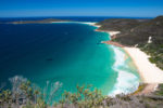
Between the endless horizons of the Western Plains and the rolling hills of the eastern highlands, Warrumbungle mountains are the place where ‘east meets west’. Here, the tropical plants of the moist coastal fringe overlap with the dry inland vegetation communities creating a medley of habitats inhabited by a wide variety of Australia’s weird and wonderful animals.
The park is also one of Australia’s Dark Sky Reserves and the night sky in Warrumbungles is spectacular. It is by far one of the best places to see the Milky Way in NSW and possibly all of Australia.
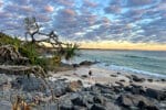
But the most mesmerizing features of the Warrumbungles are the towering rock formations – the remnants of a great pile of volcanic debris, millions of years old. The spectacular Breadknife and Grand High Tops walk in Warrumbungle National Park is by far the best way to experience this ancient landscape. The walk is jaw-dropping, even if you know nothing about Warrumbungles. But to truly appreciate this awe-inspiring landscape, you need to understand why it is so unique.
When we planned our trip to the Warrumbungles, I couldn’t find any detailed descriptions of the Breadknife walk online. There were bits and pieces of information here and there, but nothing that would give me a good idea of what to expect from the Breadknife and Grand High Tops walk, how difficult it is, what are the main points of interest or what is so special about the landscape. So I’ve put together this guide of the walk to help you plan your Warrumbungles adventure.
Volcanic making of the Warrambungles
The story of Warrumbungles begins 17 million years ago when the Warrumbungle volcano came to life, ejecting vast amounts of ash, rocks and viscous lava called trachyte. This trachyte lava was too thick to flow far from the vents, so it accumulated around them, forming massive lava domes and eventually blocking the vents. As more lava flow rose from the earth’s core, new vents were created, and the volcano kept growing like a giant shield over the plains. These eruptions lasted a mind-boggling 3 million years.

By 14 million years ago, the volcano started to cool off, and the viscous trachyte lava was replaced by the more fluid basalt. Basalt lava flowed well away from the vents into the surrounding plains and almost entirely covered trachyte deposits. By the time Warrumbungle volcano came to the end of its life 13 million years ago, it was a wide shield-shaped mound, 50 kilometres across and 1000 meters high.
Over the following 13 million years, wind and rain eroded the massive structure, stripping off layers of ash and the softer basalt lava to reveal the inner structures of the volcano. The spires, domes, plateaus, and dykes you see at Warrumbungles today are the remnants of the earlier phases in the volcano’s life. And while today these formations project above the surrounding countryside, they were formed underground beneath the dome of the volcano that had since eroded away. So, a visit to Warrumbungle National Park is an incredible journey inside a volcano.
What does Warrumbungle mean?
Warrumbungle mountains have a rich Aboriginal history that stretches back at least 5,000 years. The name ‘Warrumbungle’ comes from the Gamilaraay language of the Kamilaroi people and is believed to mean ‘Crooked mountains’.
The most dramatic features of the Grand High Tops walk
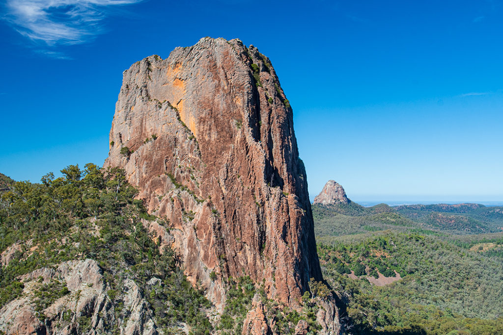
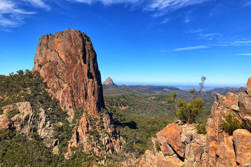
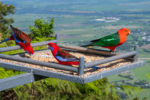
Breadknife
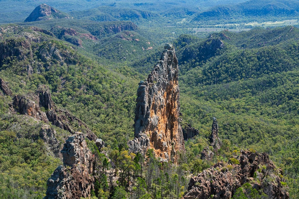
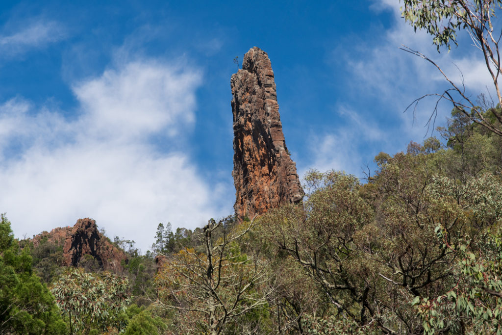
The Breadknife is the most recognizable landmark of Warrumbungle National Park and one of the most spectacular rock formations in Australia. It is what is known as a dyke – a structure formed when lava flows into a long narrow fissure in the rock beneath the surface of the volcano. When the lava cools off and solidifies, it effectively forms a cast of the fissure. Over millions of years, the softer rock that made up the Warrumbungle volcano has eroded away, leaving the more resistant trachyte dykes, like the Breadknife, standing exposed.
The Breadknife is about 600 meters long, 90 meters tall at the highest point and only 2-4 meters wide. You can see just how thin the Breadknife is by looking through a unique lookout through the gap in its wall (more details below)
Belougery Spire
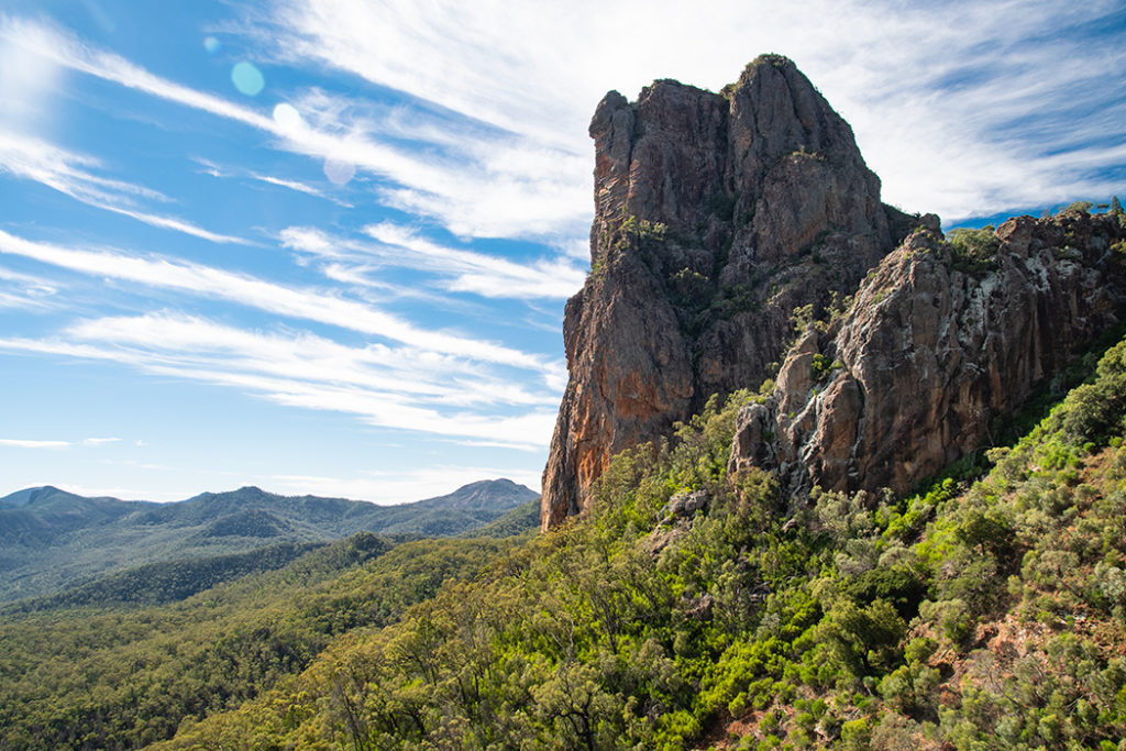
Belougery Spire is known as a neck or a plug. It dominates the landscape to your left as you climb the metal staircases and scramble up to Lugh’s Throne. It marks an underground vent through which lava erupted to the surface. When the volcano activity began to decrease, the magma rising from below cooled and solidified, plugging the vent. In time, the softer rock surrounding the plugged vent eroded away, exposing the more resistant neck. So what you are looking at here is lava travelling up!
Lugh’s Throne
Lugh’s Throne is the name of the summit that forms Grand High Tops lookout. It is the geographical and volcanic centre of the Warrumbungle volcano. The bouldery rubble surface you see at Lugh’s Throne today is the result of the cooling and solidifying of the outer skin of lava flow.
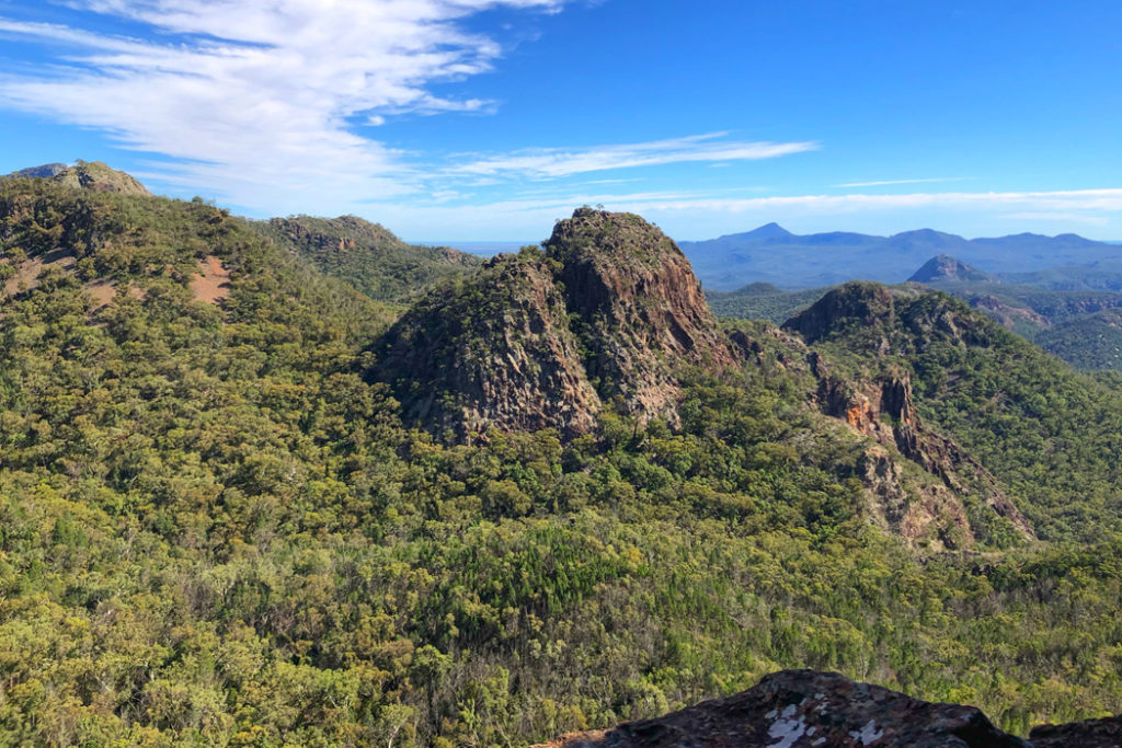
Crater Bluff and Tonduran Spire
Crater Bluff is another grand spire in the skyline you see from Lugh’s Throne. Like Belougery Spire, it is a plugged vent. Just behind it, when viewed from Grand High Tops, is another vent – Tonduran Spire.
Balor Peak

Balor Peak is visible from Lugh’s Throne directly behind Breadknife. It is also the main structure visible from the secret lookout. Like Bluff Mountain, it is a trachyte lava dome.
Breadknife and Grand High Tops walk
One of the most iconic walks in Australia, the Breadknife and Grand High Tops walk is breathtaking, both because it is so visually arresting and physically demanding. The shorter version of the walk (more details below) is 12.5 kilometres and includes a few hundred steps via metal staircases, about 300 meters of steep ascent along the base of Breadknife, and another 300 meters plus a short scramble to reach the Grand High Tops summit.
Track at a Glance
- Closest town: Coonabarabran, 35 km away
- Distance: 12.5 km loop (or 14.5 km for the full Grand High Tops Circuit)
- Time: 4-5 hrs
- Grade: 4 -the second half of the walk is quite steep and includes a few hundred steps
- Elevation gain: 642 meters
- Facilities: There is no drinking water anywhere along the track, so make sure to bring a few litres with you. Public bathrooms are available at the Pincham car park.
- Map of the walk: Pick up a map of the track at the Warrambungle NP Visitor Center on the way to the track.
- Starting Poing: Pincham car park. From Coonabarabaran, follow John Renshaw Parkway into Warrumbungle National Park and then turn left into Pincham Road about 100 meters past the Visitor Centre turnoff
Pincham car park to Spirey View – 3.1 km
The first section of the Breadknife and the Grand High Tops walk is a pleasant walk in the bush that takes you from the car park to Spirey View lookout. Here, the track follows Spirey Creek crossing it a few times over picturesque wooden bridges. Some parts of the trail have been paved, while other parts were left as dirt trail. It’s a lovely walk, especially the second half of it, when you find yourself walking in the shadow of the towering lava domes.

Spirey View lookout is only 100 meters off the main track so it’s an easy detour. The lookout is made up of a few large boulders at the edge of an escarpment looking out onto the main volcanic formations of the track: the Breadknife, Belougery Spire and the Grand High Tops.
Spirey View to the base of the Breadknife – 1.7 km
This is where the track starts getting serious. Shortly after the Spirey View turn off the track takes a sharp right turn and begins to ascend the Breadknife via Spirey Ramp. The first 1.4 km of the assent are covered by the paved trail.
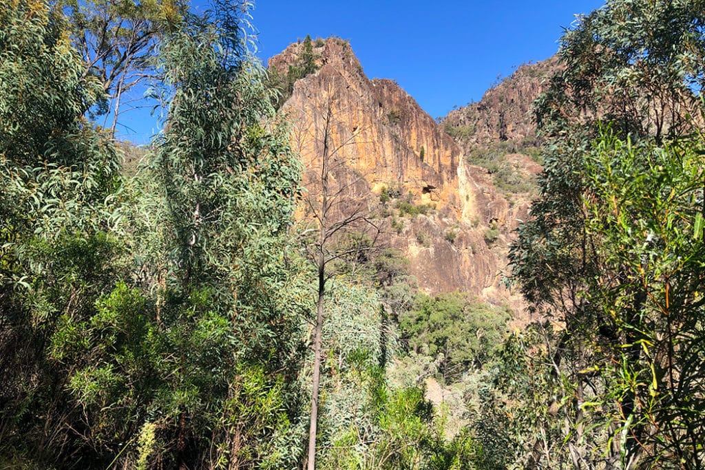
Despite the increasing steepness, it is not a difficult trail to walk and the landscape becomes more and more spectacular the higher you climb. The 90-meter-high pillar of the Breadknife towers over the tree line directly ahead, Belougery Spire rises from the valley on the left and the sheer wall of the Breadknife dominates the view on the right. With its towering peaks, cypress pines, and jagged skylines, this patch of the trail looks more like Yosemite National Park than Australian Warrumbungles.
The sealed path terminates at the foot of the metal stairway. From this point on, there are a few hundred steps to climb, plus 300 meters of steep ascent to the summit. You may have heard a reference to 1,000 steps on the way to the Grand High Tops. I am happy to be the one to tell you, that this is incorrect. The 1,000 steps are located on a different track – the Fan’s Horizon. Although the steep climb up the stairs along the Breadknife to Grand High Tops may feel like a thousand steps too.

Tip: If you don’t fancy the steps and steep scramble at the end, you can take the Dagda shortcut trail to the top. Most people take the shortcut on the way down, but you could also take it on the way up. But keep in mind, by avoiding the steepest part of the track, you also miss out on the walk along the base of the Breadknife, and a secret lookout through a gap in its towering wall. To find the start of the Dagda shortcut, climb the first few flights of stairs until you see a sign for Dagda Gap.
If you decide to tackle the stairs, you’ll be treated to jaw-dropping views. As you climb, you see Belougery Spire from different angles and it looks slightly different each time you see it. Keep in mind that what you are looking at is solidified magma travelling upward through what used to be a volcanic vent that had eroded away over the past 13 million years.
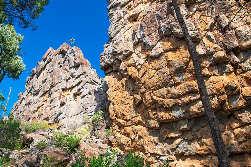
Once you reach the top of the stairs, the trail narrows and takes you to the base of the Breadknife. This is as close as you get to this fascinating formation. Here, you are walking past the monolithic wall of solidified lava that is about 17 million years old. Before long you will walk past a v-shaped gap in the wall where you can see the unusual pattern of hexagonal cracks in the rock that look remarkably similar to the pattern of Sawn Rocks in the nearby Mt Kaputar National Park, only here the columns are horizontal.
Soon you come to a fork in the trail with two somewhat undefined trails to choose from. These two trails meet again after about 50 meters and both of them travel parallel to the base of the Breadknife. But you’ll have a different experience depending on which trail you pick. If you would like an easier path, take the left (lower) trail. It is a well-formed sandy trail, easy to walk on.
But if you don’t mind some scrambling and would like to see an incredible view through the gap in the sheer wall of the Breadknife, take the right (upper) path.
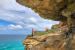
Secret Lookout through a gap in the Breadknife
The upper trail takes you within touching distance of the Breadknife – you’ll scrape against its monolithic wall as you scramble over rocks at its base. I discovered the secret lookout completely by accident. Fascinated by the rock wall, I followed the path to the right, all the while wondering why the Park Ranger at the Visitor Centre didn’t mention this fairly difficult section – he mentioned the 10-meter scramble just before the summit, but this was much longer than 10 meters. It was more of a pile of rocks than a path and I often had to use my arms to lift myself up as I scrambled over them. It wasn’t too difficult, just unexpected.
About halfway along, I came across a local couple who alerted me to the fact that this was not actually the main trail and then pointed to a gap in the wall of Breadknife and told me it was a local secret – a little-known lookout with a stunning view of the valley and Balor Peak.
The gap is large enough to climb into, although there is no flat bottom. Instead, you’ll be balancing on the narrow vertical edges of rock sheets that make up the Breadknife. So you’ll need to be very careful where you put your feet and take your time.

The uninterrupted view of the valley from this lookout is quite amazing, but my favorite part was being able to climb inside the Breadknife and see just how thin the formation really is. It’s no more than 2 meters wide at this point. Like a massive skyscraper with just one wall.
Once you are back on the rocky trail, veer left through the bush until you join the main path below. The two paths travel parallel one another, so you just need to descend a few meters to the main path.
Base of the Breadknife to Grand High Tops summit – 300 meters
Once you re-join the main trail you soon walk past a signpost announcing that the summit is only 300 meters away. These are going to be some of the steepest 300 meters of the walk, but the end is in sight, so keep your eyes on the prize.
If you followed the easy path along the base of the Breadknife, the last 10 or so meters to the summit will be the only scramble you have to do on the entire Breadknife and Grand High Tops walk.
Once you emerge on top of the range at Lughs Throne (960 meters) that lies at the centre of the Grand High Tops, you’ll realize that the tough climb was entirely worth it. The view of the valley and the jaw-dropping jumble of domes, spires, dykes and ridges are like nothing you’ve ever seen before. To the east, Belougery Spire towers over the landscape, to the north, the Breadknife stretches in a jagged line in front of Balor Peak, and to the south, the impressive pillar of Crater Bluff dwarfs the distant Tonduran Spire.
The Grand High Tops lookout is the perfect place to have some lunch and soak up the incredible scenery. There are plenty of spots to get views of different features in the surrounding valley. You could also climb the Lugh’s dyke, which is thought to be the continuation of the Breadknife.
Return via Dagda Shortcut – 6.3 km
Once you are ready for the return journey, cross the Grand High Tops summit heading west and take up the (unmarked) Grand High Tops track. The trail starts with a steep descend and then levels out travelling through the forest for about 650 meters to Dagda Saddle intersection.
For a longer walk, you could continue along the Grand High Tops trail to complete the full 14.5km circuit. Or you could take the Dagda shortcut on your right and shave about 2km off the walk.
The shortcut trail is a much easier way to descend from the summit (you could also take it on the way up if you don’t mind missing some of the best views along the way). It takes just over a kilometre to meet the main trail travelling around the other side of the Breadknife. There is a nice lookout about halfway along the shortcut trail with a good view of Balor Peak.
The trail ends quite unexpectedly at the last couple of flights of the metal stairway. Not only do you avoid the knee-jarring descent from the summit of the Grand High Tops, but you also skip most of the stairs by taking the shortcut trail!

From here, you retrace your steps back to Pincham car park. If you haven’t visited Spirey View lookout on the way up, take the short detour on the way down to get a different perspective on the summit you just visited and the rugged line up of the Grand High Tops.
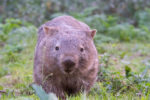
Wildlife of Warrumbungles
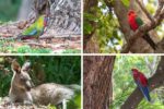
As you explore the trails in the Warrumbungles you may spot some of the parks wild inhabitants especially early in the morning and late in the afternoon. The park is home to the adorable brush-tail rock wallabies, although they are quite shy and not easy to see here (you would have better luck spotting them at Jenolan Caves in the Blue Mountains). But you certainly see a lot of their scat on the upper reaches of the track.
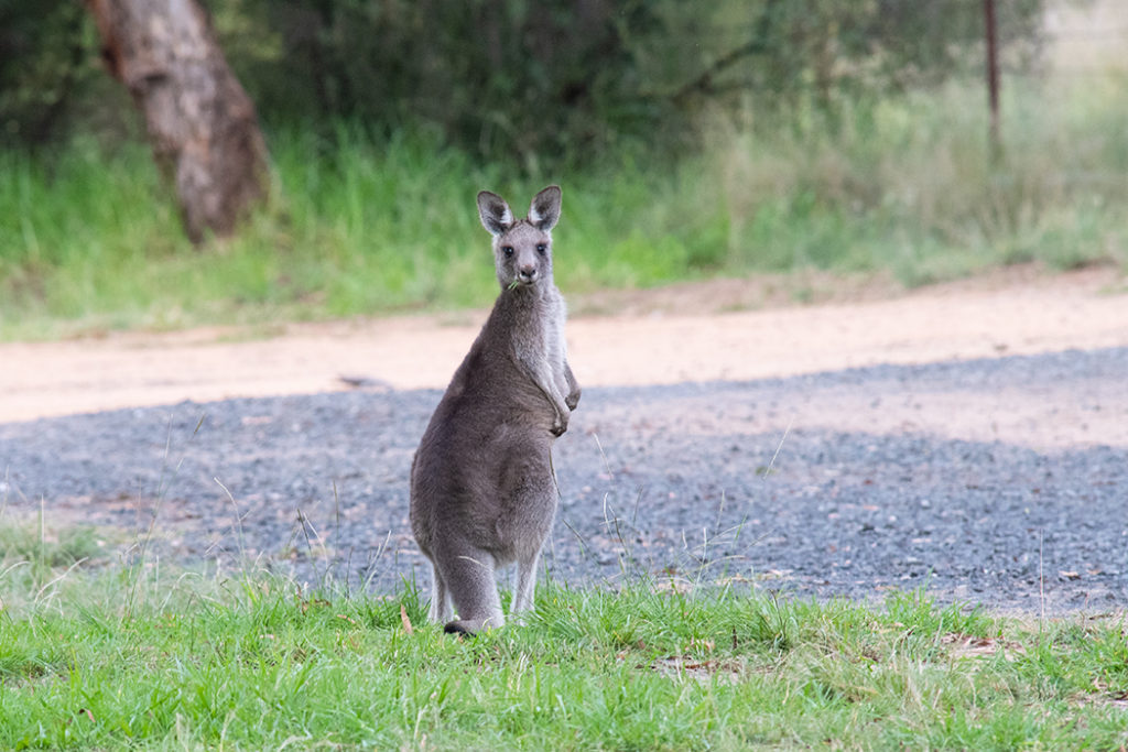
Much easier to spot are the eastern grey kangaroo, red-necked wallaby and swamp wallaby. The two wallabies are quite easy to tell apart – the red-necked wallaby has light grey fur with a reddish wash above the shoulders and back of the neck. The swamp wallaby is much darker with a dark brown or even black back, and a light yellow or rufous orange chest.
Echidnas are also quite common in the park so keep an eye out for them if you hear rustling on the forest floor.
The most noticeable reptiles in the park are the lace monitors and sand goannas. In the summer months, snakes can be found sunning themselves on or near the trails. During the busy times of the year, when there is a lot of activity on the Breadknife and the Grand High Tops walk, you are quite unlikely to spot the snakes unless you are one of the first people on the trail in the morning. But on quieter days, when no one has disturbed the snakes, you could spot them near the walking trail
Snakes get a bad rap and people tend to be terrified of them, but they have no more interest in encountering you than you in encountering them. They would prefer to retreat rather than have a confrontation. So if you spot a snake on the trail, give it a chance to retreat. Among the venomous snakes in the Warrumbungles are the red-bellied snake, eastern brown snake and king brown snake.
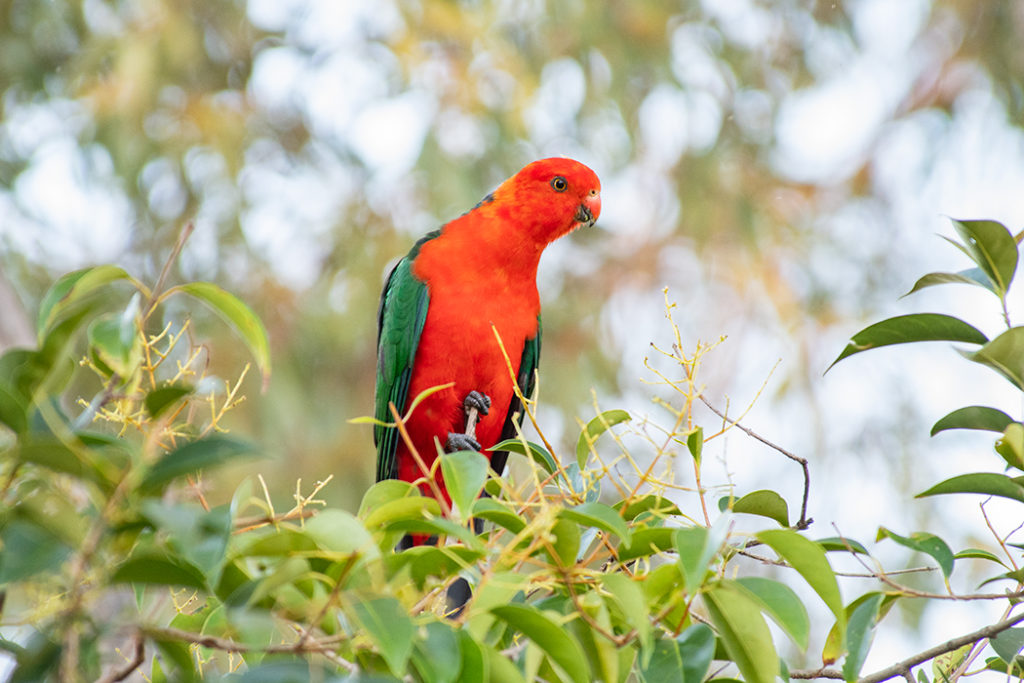
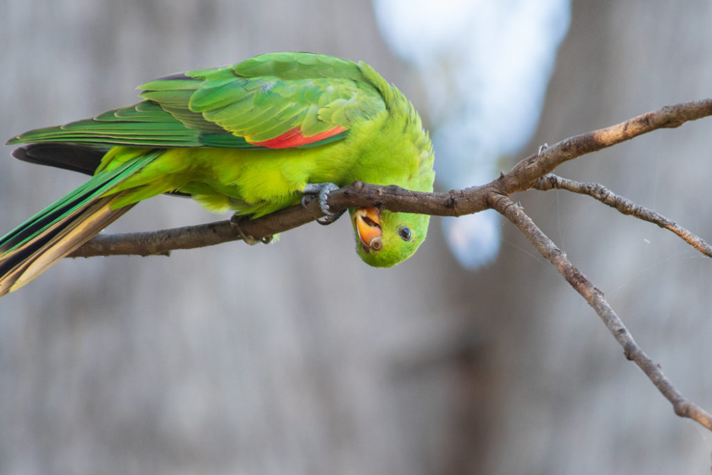
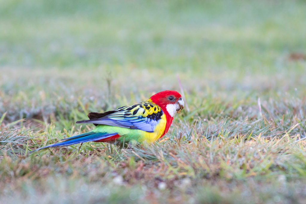
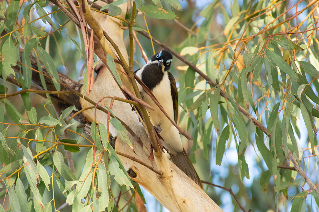
The birdlife in the Warrumbungles is extraordinarily diverse. Some of the most colourful birds you might spot are the parrots: sulphur-crested cockatoos, galahs, eastern and crimson rosellas, king parrots, red-winged parrots, blue bonnets and small lorikeets are all present in the park. Harder to spot is the endangered turquoise parrot.
Emus are more at home on the surrounding plains but can also be spotted in the lower areas of the national park. There are 15 species of birds of prey living in the park including the wedge-tailed eagle, brown falcons and peregrine and nankeen kestrels.
Campsites are usually quite good for spotting birds, but you can see and definitely hear a few species from the Breadknife walk as well.
How to get to the Warrumbungles
Warrumbungle National Park is 524 km from Sydney and 35 km from Coonabarabran. There are a few routes between Sydney and Coonabarabran: via Mudgee, via Quirindi, or via Merriwa. Once in Coonabarabran, follow the signs for Warrumbungle National Park travelling along Timor Road/John Renshaw Parkway. Within the National Park, turn right from John Renshaw Parkway and drive for approximately 300 meters to the visitor centre.
Where to stay near the Warrumbungles
Coonabarabran is the most convenient town to base yourself in for exploring the Warrumbungles region. The main accommodation in town are motels strung along Newell Highway (check the options here). One of the most popular options is the family-run Acacia Motor Lodge (check availability here)
For something different, check out Farkala Farmstay (check availability here) where you can stay at a little cottage on a large farm.
Or if you are looking for a quick overnight stay in town, the Imperial Hotel (check availability here) is located 400 meters from the town centre.
Around the Warrumbungles
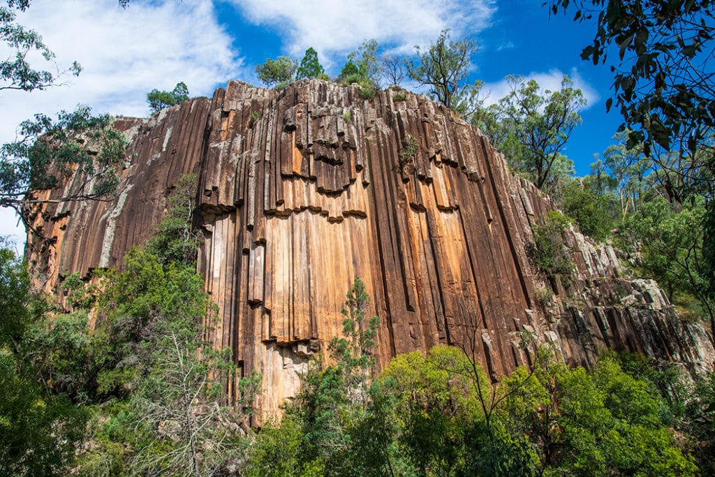
Sawn Rocks: Another stunning volcanic formation is the Sawn Rocks in the nearby Mount Kaputar National Park. Here you can see a striking example of rock formation called ‘organ-piping’. This unusual pentagonal shape of the rocks can also be seen in the Breadknife, but it is much more defined in Sawn Rocks. Organ pipes are formed when basaltic lava cools off slowly and evenly, allowing the crystals within the molten rock to align perfectly with each other.

Sandstone Caves: Tucked away in Pilliga forest, sandstone caves are some of the finest caves you’ll see in Australia. It is a series of caves carved by wind and rain in the side of a sandstone escarpment. Some of the caves are joined by passages making them two or even three-chamber structures. The caves are of high cultural significance to Gamilaroi people – ancient aboriginal carvings can be seen in some of the caves.
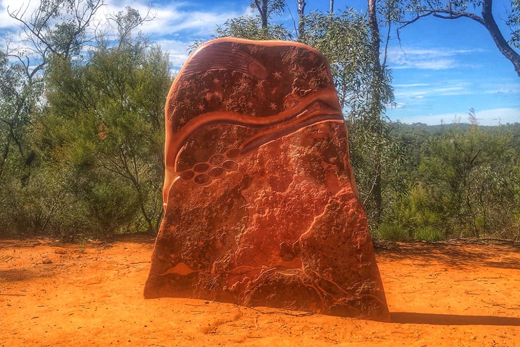
Sculptures in the Scrub: Also in Pilliga forest, Sculptures in the scrub is a beautiful walk along the top of Dandry Gorge decorated by five sets of sculptures. Each sculpture is a collaboration between an artist and local Aboriginal Elders that tells a story of local Aboriginal history and culture.
Framed by the orange hues of Australia’s iconic red dirt, it is a very atmospheric place to explore.
More Nature Adventures in NSW
- 30 Amazing Things to Do in Port Stephens

- Nelson Bay Dolphin Cruise & Sand Dunes Tour Review
- A weekend on the Tweed Coast and beyond
- Finding Fireflies and Glow Worms in the Blue Mountains

- Unmissable Things to do in Narooma & the surrounding countryside
- 40 Fun Things to do in Kangaroo Valley
- Walking with Wombats in Kangaroo Valley – Tour Review
- Tomaree Head Summit walk – How to see the best views in NSW
- Wildlife Wonders of Green Patch in Booderee National Park, Jervis Bay
- Sydney to Narooma Road Trip: What to see and Where to stop

Glad ive found your blog! Thank you doe documenting everything so beautifully. Do you think camping close to the top and heading up for sunrise is possibility?
Hmmm, I haven’t paid specific attention, but I can’t imagine camping anywhere along this trail. It’s super steep and narrow. There are a few designated camping areas in the park, so you could drive to the start of the walk and do the hike at night to reach the summit in time for sunrise. The trail is well-established so you shouldn’t have a problem. The only bit that might be a bit tricky in the dark is right at the top.
Hi Margarita . Thank you for a most interesting and helpful post and I love the photos too . Great work ! – Klaus .
Thank you, Klaus :)
Hi, great post! I was wondering if the photo you took of belougery spire was from the top of the stairs or if it was taken at the grand high tops lookout?
Thanks,
Chris
Thank you, Chris. The image in this post is from the top of the stairs.
Wow the landscape here is incredible and really reminds me of a hike I did in southern Spain called El Torcal.
What a fabulous hike! The rock formations are really interesting. I love the section on wildlife too. Definitely saving this for if I ever make it to the area